- Catalogs
- Intergraph
- GeoMedia®
GeoMedia®
1 /14Pages

GeoMedia®
1 /14Pages
Catalog excerpts

Flexible & Dynamic GIS Management
Open the catalog to page 1
GeoMedia Maps present data visually, allowing you to visualize location and gain other information from your data. Making the information-gathering process easier—making a good map—requires powerful analytical tools and clear symbolization. Whether updating land and tax records, analyzing traffic flow and accidents, or determining the best locations for evacuation centers, GeoMedia combines tabular and geographic data to produce actionable information. GeoMedia is offered within the Producer Suite® of the Power Portfolio®. The Producer Suite empowers you to collect, process, analyze and understand...
Open the catalog to page 3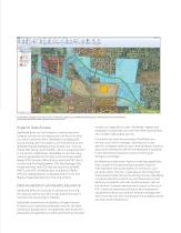
As information changes in your data sources, so does the analysis in your GeoMedia GeoWorkspace. Simply refresh and all the analysis is dynamically updated. No need to go back and re-do the work. Superior Data Access GeoMedia gives you the freedom to spend less time trying to connect to your data so you can focus on what you want to achieve with it. GeoMedia is a leading GIS choice among users who want to connect directly to the spatially enabled databases they already use—such as Oracle, SQL Server, and PostGIS—without using importers or converters. Additionally, GeoMedia can access many common...
Open the catalog to page 4
GeoMedia’s data analysis capabilities let you conduct very simple or very complex analysis of your data in order to extract the information you need. Sophisticated, Dynamic Analysis GeoMedia gives you the power to perform sophisticated analysis to extract information from data stored in multiple databases on different platforms and a variety of different files, all at once. It also enables you to create queries of unlimited intricacy, creating and concatenating queries together so that the results of one query feed into another query dynamically. As the data changes, GeoMedia updates the results...
Open the catalog to page 5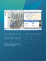
Directly connect and search an ERDAS APOLLO catalog for a variety of datasets (raster and vector) to be brought into the Map Window for viewing and analysis. Due to these unique analysis advantages, GeoMedia is the ideal platform to manage linear networks that are the mainstay of agencies who operate and maintain roads, railroads, transit, pipelines, or waterways. These analysis capabilities allow you to track information about your network and perform specialized analyses to help make better decisions about public safety, maintenance priorities, and the expenditure of funds. GeoMedia supports...
Open the catalog to page 6
Spatial Modeler in GeoMedia Hexagon’s ERDAS IMAGINE has delivered Spatial Modeler for visually authoring simple-to-complex workflows using raster and feature operations, and Spatial Modeler is delivered with GeoMedia also. Many capabilities, some only available using GeoMedia or GeoMedia Image commands, can now be used with Spatial Modeler to process files, data, or other information that previously required programming or building GeoMedia custom commands. Enterprise Productivity Productivity and accuracy are essential aspects of vector feature capture and editing for enterprise geospatial databases....
Open the catalog to page 7
As information changes in your data sources, so does the analysis in your GeoMedia GeoWorkspace. Simply refresh and all the analysis is dynamically updated. No need to go back and re-do the work. GeoMedia Professional GeoMedia Professional includes all the features of the Essentials and Advantage tiers plus enterprise-wide, multi-user data management and analysis. Manage linear networks, produce professional cartographic maps, conduct advanced feature editing, manage parcel holdings, conduct utility network analysis, monitor and control changes, integrate data from multiple sources, design and...
Open the catalog to page 8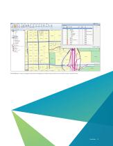
With GeoMedia it is easy to manage the placement and appearance of labels using a variety of rules in either a static or dynamic format.
Open the catalog to page 9
Manage Data Raster Toolbox Customize Ribbon A Labels of Major Cities (8) (j^)| Highwaylnterchange £i_|ljfj)| HighwayMarker /k/ Canal (2) tj /••/ Intermittent - Single Line (7) Kj /x/Perennial - Double Line (88) tj /s/ Perennial - Single Line (48) H)| Counties segmentation Attributes Downhill Path... regon Add Conflation Links ^ Adjust Linear Conflation Links Automated Validation Ejj, Create Conflation Link Queues Create Conflation Links -A Detect Void Areas Digitizer Mode %. Digitizer Setup Digitizer Setup Edge Match U Generate Base Geometry [ ] Generate Base Geometry W(. Interactive Edge Match...
Open the catalog to page 11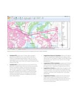
Mapping professionals can easily make beautiful maps with the cartographic style toolsets available in GeoMedia. GeoMedia PDF allows users to create highly intelligent georeferenced PDF files from map sheets in the layout window of a GeoMedia GeoWorkspace. Users can control characteristics such as order of layers, included attributes, CMYK/RGB output color model, and number of exported map sheets to PDF files. GeoMedia VPF provides a production environment for the generation of digital map products and utilizes various data sources, including re-usable, multi-product vector data from the user’s...
Open the catalog to page 12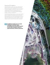
Seamless GIS Integration GeoMedia helps you easily unlock and understand the dynamic stream of real-world geospatial information that flows through your organization. It lets you conduct a variety of analyses, from the very simple to the very sophisticated, on data from disparate sources. It connects directly to the spatially enabled databases already in use by your organization. GeoMedia allows deep analysis and dynamically updates results. Its flexible tier and add-ons structure let you tailor the system to your specific business requirements. GeoMedia empowers you to create intelligent, intuitive...
Open the catalog to page 13
Hexagon is a global leader in sensor, software and autonomous solutions. We are putting data to work to boost efficiency, productivity, and quality across industrial, manufacturing, infrastructure, safety, and mobility applications. Our technologies are shaping urban and production ecosystems to become increasingly connected and autonomous — ensuring a scalable, sustainable future. approximately 4.3bn USD. Learn more at hexagon.com and follow us @HexagonAB. © 2019 Hexagon AB and/or its subsidiaries and affiliates. All rights reserved. Hexagon and the Hexagon logo are registered trademarks of...
Open the catalog to page 14All Intergraph catalogs and technical brochures
 Leica CloudWorx? for PDS®
2 Pages
 SmartPlant® Cloud
2 Pages
 PV Elite
2 Pages
 CAESAR II
2 Pages
 PDS Ortho-Draw Product Sheet
2 Pages
 PDS Product Sheet
2 Pages
 SmartSketch Product Sheet
2 Pages
 SmartPlant 3D Product Sheet
2 Pages
 SmartMarine 3D Product Sheet
2 Pages


- Design software
- 3D software
- Industrial management software
- Analysis software
- Steel structure software
- 2D software
- Architecture software
- 2D/3D object library
- Computer-aided engineering software
- Electrical installation software
- Project management software
- Simulation software
- Mapping software
- Project simulation software
- Image editing software
- Sustainable design software